®
Fall 2019
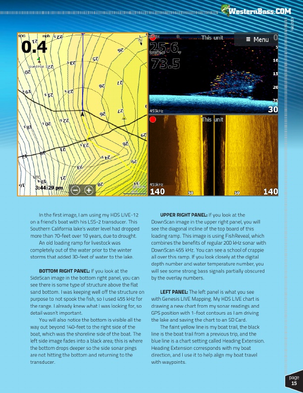
In the first image, I am using my HDS LIVE-12 on a friend’s boat with his LSS-2 transducer. This Southern California lake’s water level had dropped more than 70-feet over 10 years, due to drought.
An old loading ramp for livestock was completely out of the water prior to the winter storms that added 30-feet of water to the lake.
BOTTOM RIGHT PANEL: If you look at the SideScan image in the bottom right panel, you can see there is some type of structure above the flat sand bottom. I was keeping well off the structure on purpose to not spook the fish, so I used 455 kHz for the range. I already knew what I was looking for, so detail wasn’t important.
You will also notice the bottom is visible all the way out beyond 140-feet to the right side of the boat, which was the shoreline side of the boat. The left side image fades into a black area; this is where the bottom drops deeper so the side sonar pings are not hitting the bottom and returning to the transducer.
UPPER RIGHT PANEL: If you look at the DownScan image in the upper right panel, you will see the diagonal incline of the top board of this loading ramp. This image is using FishReveal, which combines the benefits of regular 200 kHz sonar with DownScan 455 kHz. You can see a school of crappie all over this ramp. If you look closely at the digital depth number and water temperature number, you will see some strong bass signals partially obscured by the overlay numbers.
LEFT PANEL: The left panel is what you see with Genesis LIVE Mapping. My HDS LIVE chart is drawing a new chart from my sonar readings and GPS position with 1-foot contours as I am driving the lake and saving the chart to an SD Card.
The faint yellow line is my boat trail, the black line is the boat trail from a previous trip, and the blue line is a chart setting called Heading Extension. Heading Extension corresponds with my boat direction, and I use it to help align my boat travel with waypoints.
page
15