SonarCharts
A high definition bathymetry map layer for GPS plotters!
advertorial special section ™
Press release
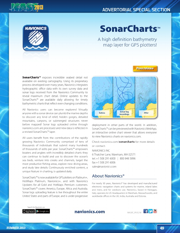
SonarCharts™ exposes incredible seabed detail not available on existing cartography. Using its proprietary process developed over many years, Navionics integrates hydrographic office data with its own survey data and sonar logs received from the Navionics Community to reveal maximum chart detail. Online updates to the SonarCharts™ are available daily allowing for timely bathymetric charts that reflect ever-changing conditions.
All Navionics users can become explorers! Virtually anyone with a sonar device can plumb the marine depths to discover any kind of relief, hidden gorges, detailed mountains, canyons, or submerged structures never before mapped! Sonar logs uploaded online through navionics.com are processed and new data is reflected in a revised SonarCharts™ layer.
All users benefit from the contributions of the rapidly growing Navionics Community comprised of tens of thousands of individuals that submit many hundreds of thousands of edits per year. SonarCharts™ empowers boaters and anglers with incredibly detailed charts they can continue to build and use to discover the ocean’s sea beds, venture into creeks and channels, target the most productive fishing areas, explore new diving areas, and study lake details. Continuously enriched content, a unique feature in charting, is updated daily.
SonarCharts™ is now available for GPS plotters on Platinum+, HotMaps Platinum, Navionics+, and with Navionics Updates for all Gold and HotMaps Premium customers. SonarCharts™ covers America, Europe, Africa and Australia. Sonar logs uploading feature is live throughout the entire United States and parts of Europe, and is under progressive
deployment in other parts of the world. In addition, SonarCharts™ can be previewed with Navionics WebApp, an interactive online chart viewer that allows everyone to view Navionics charts on navionics.com.
Check navionics.com/ sonarcharts for more details or contact:
NAVIONICS INC 6 Thatcher Lane, Wareham, MA 02571 tel. +1 508 291 6000 | 800 848 5896 fax +1 508 291 6006 sales@navionics.com
About Navionics®
For nearly 30 years, Navionics® has developed and manufactured electronic navigation charts and systems for marine, inland lakes and rivers, and for outdoors use. Navionics, based in Viareggio, Italy, operates its US Headquarters in Wareham, Massachusetts, and worldwide offices in the UK, India, Australia and Estonia.
Search for Navionics on
navionics.com
NAV287_PR/SC/NI
summer 2013
49
http://www.navionics.com/sonarcharts http://www.navionics.com