Ask The Sonar Guys is a regular feature every issue where Jeff Boyer from Sonar GPS Workshops LLC answers
your questions about operating, interpreting, and getting the most from your sonar and gps units. Email any questions you may have to jeff@sonargpstraining.com, and Jeff will pick one or two to answer in the next issue. The
next question could be yours, so send them in.
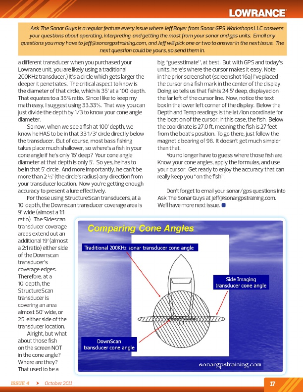
a different transducer when you purchased your lowrance unit, you are likely using a traditional 200KHz transducer.) it’s a circle which gets larger the deeper it penetrates. The critical aspect to know is the diameter of that circle, which is 35’ at a 100’ depth. That equates to a 35% ratio. Since i like to keep my math easy, i suggest using 33.33%. That way you can just divide the depth by 1/3 to know your cone angle diameter.
So now, when we see a fish at 100’ depth, we know he HaS to be in that 33 1/3’ circle directly below the transducer. But of course, most bass fishing takes place much shallower, so where’s a fish in your cone angle if he’s only 15’ deep? Your cone angle diameter at that depth is only 5’. So yes, he has to be in that 5’ circle. and more importantly, he can’t be more than 2 ½’ (the circle’s radius) any direction from your transducer location. Now you’re getting enough accuracy to present a lure effectively.
For those using StructureScan transducers, at a 10’ depth, the downscan transducer coverage area is 9’ wide (almost a 1:1 ratio). The Sidescan transducer coverage areas extend out an additional 19’ (almost a 2:1 ratio) either side of the downscan transducer’s coverage edges. Therefore, at a 10’ depth, the StructureScan transducer is covering an area almost 50’ wide, or 25’ either side of the transducer location.
alright, but what about those fish on the screen Not in the cone angle? Where are they? That used to be a
big “guesstimate”, at best. But with GPS and today’s units, here’s where the cursor makes it easy. Note in the prior screenshot (screenshot 16a) i’ve placed the cursor on a fish mark in the center of the display. doing so tells us that fish is 24.5’ deep, displayed on the far left of the cursor line. Now, notice the text box in the lower left corner of the display. Below the depth and temp readings is the lat/lon coordinate for the location of the cursor; in this case, the fish. Below the coordinate is 27.0 ft, meaning the fish is 27 feet from the boat’s position. to go there, just follow the magnetic bearing of 98. it doesn’t get much simpler than that.
You no longer have to guess where those fish are. Know your cone angles, apply the formulas, and use your cursor. Get ready to enjoy the accuracy that can really keep you “on the fish”.
don’t forget to email your sonar/gps questions into ask The Sonar Guys at jeff@sonargpstraining.com. We’ll have more next issue.
Issue 4 October 2011
17
mailto:jeff@sonargpstraining.com